Archive for the 'Maps' Category

REMEMBER WHEN THESE WERE FREE?

MAP 1962
1962

posted by Bob Karm in Blog question,Gas stations,HISTORY,Maps,Memorabillia,Remember these? and have No Comments

LOCAL HISTORY WAS MADE IN 1978

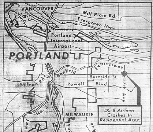
December 28, 1978: United Airlines DC-8 Crashes in Northeast Portland - Dave Knows Portland
December 28, 1978

United Airlines Flight 173 was a scheduled flight from John F.
Kennedy International
Airport
in New York City to Portland
International Airport
in Portland, Oregon, with a scheduled
stop in
Denver, Colorado.

On Thursday, December 28, 1978, the aircraft flying this route
ran out of fuel while troubleshooting a landing gear problem
and crashed in a suburban
Portland neighborhood
near NE
157th Avenue and East
Burnside Street.

(From Wikipedia, the free encyclopedia)

The 1978 Burnside Airplane Crash | Portland Monthly

United Airlines Flight 173, Portland, OR - Plane Crash Sites on Waymarking.com

See the source image

A Watershed Event - IFR Magazine

United Airlines Flight 173 ATC Recording (With subtitles) - YouTube
Crash of a Douglas DC-8-61 in Portland: 10 killed | Bureau of Aircraft Accidents Archives

United Airlines Flight 173 crash site in Portland, OR - Virtual Globetrotting
The crash site as it looks today.

posted by Bob Karm in Air disaster,AIRCRAFT,ANNIVERSARY,Aviation disaster,DEATH,HISTORY,Maps,NEWSPAPER,THEN AND NOW and have No Comments

THE 47th STATE ON THIS DAY IN 1912

New Mexico timeline | Timetoast timelines
On January 6, 1912, New Mexico was admitted into
the United States as the 47th state.

Spanish explorers passed through the area that would
become New Mexico in the early 16th century, they
encountered the well-preserved remains of a 13th-
century Pueblo civilization. Exaggerated rumors about
the hidden riches of these Pueblo cities encouraged the
first full-scale Spanish expedition into New Mexico, led
by Francisco Vasquez de Coronado in 1540. Instead of
encountering the long-departed Pueblo people, the
Spanish explorers met other Indigenous groups, like
the Apaches, who were fiercely resistant to the early
Spanish missions and ranches in the area.

Statehood during Western Expansion 1876 - 1912 timeline | Timetoast timelines

Francisco Coronado
Francisco Vázquez de Coronado
(1510 – 22 September 1554)

New Mexico - joined the United States as the 47th state on January 6, 1912. The capital is Santa ...

posted by Bob Karm in ANNIVERSARY,HISTORY,Maps,Statehood and have No Comments

ERIE CANAL OPENED ON THIS DAY IN 1825

See the source image

The Canal connects the Great Lakes with the Atlantic Ocean via
the Hudson River. Governor DeWitt Clinton of
New York, the
driving force behind the project, led the opening ceremonies
and rode the canal boat Seneca Chief from Buffalo to
New York
City
.

Work began on the waterway in 1817. Teams of oxen plowed the
ground, but for the most part
the work was done by immigrants,
among them Irish diggers who had to rely on primitive tools. They
were paid $10 a month, and barrels of whisky were placed along
the canal route as encouragement.

See the source image
A painting at the Syracuse Canal Museum depicts Governor Dewitt Clinton bringing water from Lake Erie to New York
City, in the ceremony known as the “Wedding of the Waters.”

See the source image

See the source image
The Erie Canalway today.

posted by Bob Karm in ANNIVERSARY,Canal,HISTORY,Maps,Opening and have No Comments

NAVY FLIGHT 19 LOST ON THIS DAY IN 1945

See the source image

See the source image

At 2:10 p.m., five U.S. Navy Avenger torpedo-bombers comprising
Flight 19 took off from the Ft. Lauderdale Naval Air Station in
Florida
on a routine three-hour training mission. Flight 19 was scheduled to
take them due east for 120 miles, north for 73 miles, and then back
over a final 120-mile leg that would return them to the naval base.
They never returned.

Two hours after the flight began, the leader of the squadron, who
had been flying in the area for more than six months, reported that
his compass and back-up compass had failed and that his position
was unknown. The other planes experienced similar instrument malfunctions. Radio facilities on land were contacted to find the
location of the lost squadron, but none were successful. After two
more hours of confused messages from the fliers, a distorted radio transmission from the squadron leader was heard at 6:20 p.m., apparently calling for his men to prepare to ditch their aircraft simultaneously because of lack of fuel.

See the source image

posted by Bob Karm in AIRCRAFT,ANNIVERSARY,Aviation,Bermuda Triangle,Bomber,HISTORY,Maps,Missing,Navy and have No Comments